Mapping the Berlin Wall
Berlin is Germany’s biggest and most cosmopolitan city - a cultural behemoth. Adolescent energy and an experimental spirit are fused with German grit to make Berlin a haven for creative souls - carrying the mantle of the 1920’s when the city was the hub of German expressionism.
Home to over 180 museums, the longest open air gallery in the world, three Unesco world heritage sites and three grand opera houses, it is affordable, has an uber-cool art scene and a nightlife that begins at midnight and ends two days later.
But things weren’t always this way. Before the fall of the wall, Berlin was a city divided. After World War II, Germany was split amongst the Allied powers of the USA, UK, France and the Soviet Union.

At first, Berliners were permitted to move freely between sectors, but by 1960 around a thousand East Berliners a day were voting with their feet by moving to the West.
Eventually political tensions boiled over in 1961, East Germany began the building of the notorious Berlin Wall.
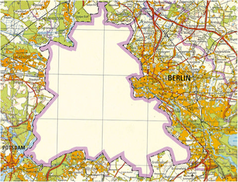
Mapmakers on the East and West were now presented with a dilemma. Neither side would be drawn in to acknowledging the legitimacy of the other.
As such, East German maps sometimes referred to the West as ‘West Berlin: The area of the occupation regime of the United States, Great Britain and France’, while referring to themselves as ‘Democratic Berlin’. Another solution was to leave West Berlin as a gaping hole.
West German maps would display the division more literally, with a redbrick wall and barbed wire.

The two very different attitudes to the wall were perhaps summed up by their attitudes to graffiti - The West Berlin side of the wall had artwork completely covering the wall, while the East Berlin side was kept blank; as people were not permitted to get close enough to the East side of the wall to paint anything.

East Germany’s eventual decision to topple the Berlin Wall was taken so quickly it happened on a smoking break.
This left map-makers facing yet more challenges. Connections between the two cities were re-established and East Germany streets and towns like Leninallee or Karl-Marx-Stadt, that had been renamed after communist heroes reverted back to their original names of Landsberger Allee and Chemnitz.
Rand McNally's Conroy Erickson said of Europe in 1991, "These are the most sweeping and dramatic changes in the history of cartography and the potential is there for ongoing change."
Shop the Berlin City Map here.